
About the McConvilles
This paper appeared as an article in 1991 publication of Emania: The Bulletin of the Navan Fort Project. We have omitted some technical portions of the original paper that dealt with the details of translating of the Ogham and the discovery of other materials at the Ogham site.
Richard Warner is Keeper of the Department of Archaeology and Ethnography for the Ulster Museum, Belfast. Mr. Warner is president of the Ulster Archaeology Society and has written extensively on Irish Archaeology and History.
Excerpts from "The Drumconwell Ogham and its Implications"
by R. B. Warner
Ulster Museum, Belfast
The Ogham Stone
Firmly set into the vestibule of the Diocesan library in Armagh is a fine ogham stone, one of only six such stones found in Northern Ireland and the only one from Co. Armagh. The stone is about 1.7 metres (5 feet) long, of which 1.4 metres is now visible. Half is of wide rectangular section (we may call this the upper part) and the other half tapers like the root of a tooth (the lower part). As it stands now the root is underground and the stone is orientated so that the wide face which bears carving is visible, the blank face being close to a wall. On the visible wide face, near its top, is a simple incised, circled cross and, on its near angles, the scores of ogham characters. The top of the stone is missing and the part nearest the top is badly damaged, removing part of the cross and any ogham strokes that might have been there
The Ogham
Ogham, or ogam, is a form of writing consisting of scores placed along a line, the scores being strokes and notches in groups representing characters. Ogham writing is most often found on large stone slabs where the angle of the stone is the line along which the scores are placed. An ogham inscription can be a single personal name or the patronymic form A son of B where A and B are personal names. The common use of the genitive for the first or only name implies an understood [something] of A (son of B) and we assume the something is the stone itself, or the inscription (as a memorial) or possibly a grave which might have been marked by the stone. Some ogham inscriptions are so well preserved that no problem arises in reading them. Others, a majority, are damaged to the extent that the reading can be difficult, or even impossible. Of those that can be read errors and spelling mistakes are not unknown
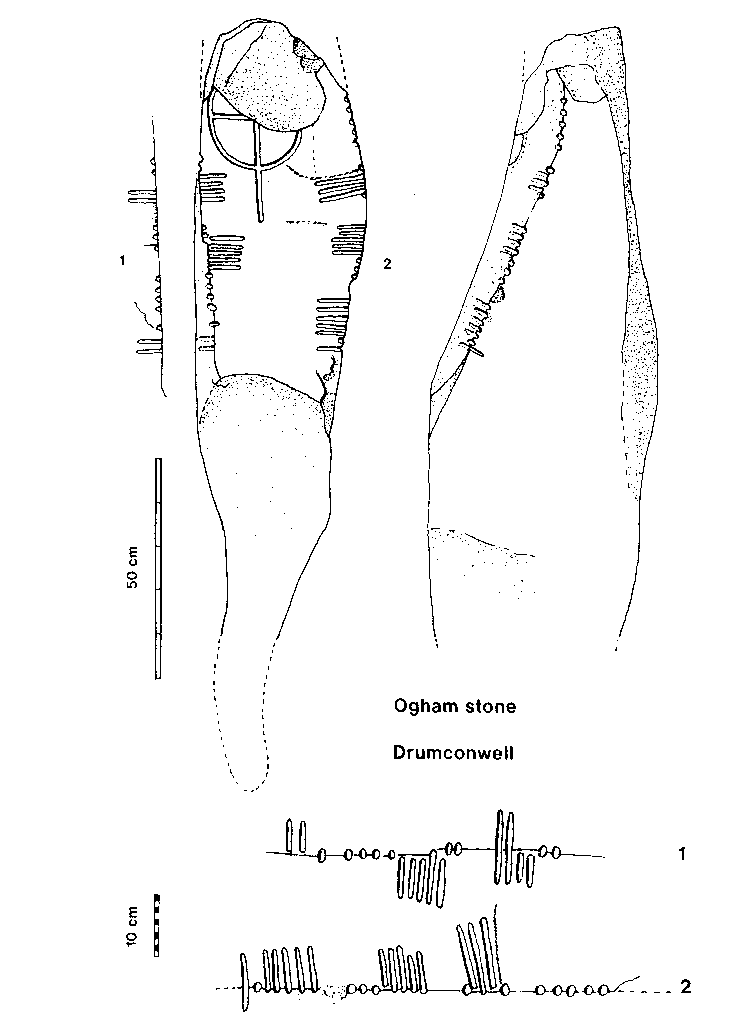
Fig. 1. Top: Front face and right side of Drumconwell stone.
Bottom: The two inscriptions. (R. Warner).
The language of most ogham inscriptions, at least those that can
be deciphered, is Primitive Irish, an earlier stage of the language that we call Old
Irish. Old Irish is the earliest form of Irish in which any true literature exists and
dates between about 600 and 900 AD (the earlier half of the Early Christian period). This
is not to say that all the ogham inscriptions necessarily predate 600 AD for although it
seems to be generally accepted that ogham was invented sometime around the 3rd century AD
(Harvey 1990), probably in Ireland, it is likely that ogham inscriptions were still being
carved as late as the eighth century. In other words it is likely that Primitive Irish
continued in use after the 6th century as an intentionally archaic written language on
ogham memorial stones (Jackson 1950). The use of archaic language is widespread in religious
speech and writings, including memorials, even at the present day. It is therefore certain
that while some ogham stones show indications
of a pagan milieu many were undoubtedly erected in a Christian society, and even
for Christians, and there is no reason why the presumably Christian cross and
the inscription should not be contemporary (Hamlin 1982, 285). The Trallwng stone has
been dated to the early 6th century by Jackson (1953, 185) but to the 7th-9th century
by Nash-Williams (1950, 81). Such is the difficulty of dating ogham inscriptions, and
simple crosses, that all we can really say is that a 5th to 8th century bracket seems
likely for ours.
The Readings
The two inscriptions are slightly damaged, and
rather imperfectly carved. They have been read by several authorities, each
reading upwards
I have studied the inscriptions carefully and the following would represent
my readings, which are slightly at variance with the other authorities
The Names
The Findspot
The stone had stood some years before 1879 in the farm of Mr. Samuel Ireland in the townland of Drumconwell, in a field called The Graveyard Field a short distance beyond his house (Pillow 1887, 164). The farm still belongs to the Ireland family, who helped me greatly in my investigations, and the Graveyard Field, which is still so-named, is immediately south of the farm-house. The field consists of the southern end of a north-south ridge extending from a ringfort capped drumlin some way to the north. This ridge end is narrow and has an abrupt scarp on the east and south and a less abrupt one on the west
Because the stone interfered with his plough, Mr. Ireland had it uprooted and rolled down the slope to the fence in the hollow (Reeves, op. cit.) where it was discovered by Mr. Pillow in 1879 and thence conveyed by him and Dr. Reeves to the Library.
I have discovered no explanation of the name Graveyard Field in terms of clear historical evidence for a religious establishment at this place, nor has Dr. Hamlin whose knowledge of the early church is unsurpassed. Nor are there traditions of bones having been unearthed during tillage. I will discuss this below. The local tradition that a prince was buried here given to me by Mrs. Ireland may be ancient, but may also be the result of the 19th century interest in the stone (see below). The field is now sheep pasture but has been ploughed on occasion. Lazy beds are clearly visible running east-west across the top of the ridge.
Drumconwell, the Hill of Conmáel
The origin of the place-name Drumconwell is not in doubt, being from Irish Druim Conmháil meaning the ridge of Conmáel (as Reeves noted in 1883, 387). In 1609, our earliest surviving reference, it was written Drumconwayll (Glancy 1954, 88). Normally there would be no reason to spend any time considering the personal name attached to an element such as Druim, as the occurrence of personal names in place-names is so common. In this case, however, the probable identification of the person named in the place-name with one of the persons on the stone requires us to explore this in some detail. The name Conmáel is not common in place-names and it is of some interest that in Co. Armagh it appears to occur twice - at Drumconwell, and at Rathconvil in the east of the county. The latter we would suspect of being Irish Ráith-Conmháil - the fort of Conmáel. We may ask ourselves who this Conmáel may have been.
The Name Conmáel
We must bear in mind that only a very few names on ogham inscriptions have been identified, without question, with known historical personages. One such is an ogham inscription from Breastagh in Co. Mayo which may be dedicated to the grandson of a fifth century AD king of the local tribe (Macalister 1945, no. 10; TPL, 126). Even rarer is an inscription bearing a name coincident with the place-name of the provenance, a possible example being a stone at Cloghanecarhane in Co. Kerry (Macalister 1945, no. 230).
We will discuss below the traditional association of the mythical Conmáel mac Ebir with the locality. First we should briefly explore the possibility that we are dealing with a historical person living in about the 6th or 7th century AD, for instance a local king. The people of most of what is now County Armagh were, in Early Christian times, known as the Airthir, or Easterners (because they were the eastern branch of the Airgialla). Before the 9th century the Airthir were, apparently, a single tribe. After the 9th century two ruling septs of the Airthir, the Ui Nialláin and the Ui Bresail became substantive tribes which, with a restricted Airthir (the present barony of Orior) and one or two other small tribes formed the federation of Airthir. From an early date the Airthir kings of the Ui Nialláin sept ruled from Loch Cal (Loughgall) just north of Armagh. The capitals of the other septs are not identified, nor are we at all sure where the septs and tribes were located in detail except that the Ui Nialláin were certainly north-east of Armagh (present baronies of Upper and Lower Oneilland). Drumconwell lay in an area called, in the 17th century, Clanconnochy (Glancy 1954, 88 & 98). This is certainly the Clann Conchobhuir whose founder was Conchobor Corrach or Conchobor Macha, late 7th century king of Airthir, of the Ui Bresail sept (CGH 333 c6). West of Drumconwell an extensive area went by the name of Toaghy, possibly from Tuath Echdach (Glancy 1954, 98). The Ui Echdach were a ruling sept of Airthir (and after the 11th century a tribe in their own right). Among their members was Conmáel son of either Conaing or Airmedach (the genealogies are inconsistent), whose genealogical position would give him a floruit of the early 7th century (CGH 146 e). His uncle (Máelodor Cáech) and distant cousin (Ronán of the Ui Bresail) were both kings of Airthir and we may suppose Conmáel was also. Another Conmáel who may well have been king of Airthir. Conmáel son of Cernach died in an intratribal battle of the Airthir in 800 (Annals of Ulster). There is some reason to believe that he was a member of the Ui Nialláin sept. The identification of two Airthir royal personages with the name Conmáel is of interest as the name is otherwise unknown in the northern royal genealogies. It was clearly a relatively popular name locally.
There are, then, a couple of historical persons called Conmáel of the Airthir, one of whom is particularly well placed chronologically and geographically to stand as a candidate for the Conmáel of Drumconwell, both place-name and inscription.
Conmáel son of Eber and Fert Conmáil
Conmael, son of Eber, having been thirty years in the sovereignty of Ireland, fell in the battle of Aenach Macha, by Tighernmas, son of Follach.
So runs the record of this event in the early 17th century compilation known as the Annals of the Four Masters (AFM), under the year of the world (anno mundi) 3579, or 1621 BC.
Conmáel was king of Ireland according to the Medieval scholars, a concept with no actual meaning at such an early date. Even the reality of named figures in pre-Christian times is rejected by modern historians, and the father of Conmáel, Eber, is simply a personification of the country (the name comes from Eberus, a Hiberno-Latin form of the Latin Hibernus, itself an inaccurate rendering of an ancient Irish ethnic or tribal name; ORahilly, 1946, 195). We need not further explore the career of this pseudo-historical Conmáel as he is of interest to us only on account of his brief, and fatal, traditional association with Oenach Macha, which we explore below.
The early 17th century historian Geoffrey Keating wrote that Conmáel, after being killed in the battle of Aonach Macha was buried on the south side (taoibh theas) of Aonach Macha, in the place (áit) which is called Feart Conmhaoil, at this day (Keating bkl, sect 25, lines 1882-4).
His contemporary Roderic OFlaherty (1685,195) wrote similarly, in his account of the death of Conmáel.
The name of his grave Feart-Conmail next to (juxta) Oenachmacha, where he fell, survives to this day.
Had the name Fert Conmáil been recorded in the old or middle Irish periods we would have translated it as the Mound of Conmáel and expected some actual surviving earthen monument. As a seventeenth century phrase Feart Chonniaoil probably means no more than the Grave of Conmáel, although the use of capital initial letters might imply that it was an actual place- or location-name. Both Keating and OFlaherty tell us that the name of the grave survived until their time, presumably locally. Unfortunately it is not attested in later maps or literature and is now lost.
Pillow (1885, 164) conjectured that Keatings Fert Conmáil was Drumconwell and it was that conjecture that led him to the discovery of the ogham stone. This belief was shared by Reeves (1883, 368) and it seems to me not at all unreasonable. If we are right in interpreting the name on the ogham as Conmáel the hypothesis is strengthened, for the stone may be interpreted as a marker for the Grave'.
It may be thought odd that we should even consider a mythical candidate for the inscription on our stone, but we have parallels for this. For instance an ogham inscription at Rathcroghan (ancient Crüachu) in Roscommon bears the names of mythical persons associated with that very place in the early heroic tales (Macalister 1945, no. 12; Waddell 1983, 33).
Oenach Macha
Fert Conmáil was at Oenach Macha, but where was Oenach Macha? The places in Co. Armagh with the Macha element have been collected together and discussed by Arthurs (1953; also Mallory 1987, 15). He was unable to locate Oenach Macha. The word óenach (this is the Old Irish form, the Middle and Modern Irish form is aenach) would tend to give the modern placename elements enagh, annagh and their variants. Unfortunately the far more common enach, a marsh, gives the same modern forms and in many cases it is impossible, even with early spellings, to distinguish between them. We have no reason therefore to suppose that any of the several Enagh townlands in Co. Armagh, one of which is south-west of Armagh and Navan, preserve the name of Oenach (Macha). It is, though, of passing interest that this particular townland of Enagh lies adjacent to a large circular enclosure (in the townland of Lisbanoe) which does not seem to be a typical ringfort, of which there are many in the district. I shall discuss this site on a future occasion.
Referring to the death of Conmáel the 17th century English translation of the Annals of Clonmacnoise, the only version of those annals we have, tell us that -
Convallo or Convoyle mcHeber was ... slaine ... in the battle of Eawyn-Vacha... (Murphy 1896, 31).
Eawyn-Vacha is Emain Macha, which we now know as the complex of earthworks at Navan. There is, then, an implication here that Oenach Macha was the same as Emain Macha. In the Annals of Ulster under the year 1021 we read of a battle between Aéd Ua Néill and the Airgialla in Aenach Macha, in which many fell in the middle of Aenach Macha. But there is, inserted into this entry, by a later hand or Ard Macha referring to the monastic site of Armagh. We cannot know whether this insertion was identifying Oenach Macha or correcting the entry. The reference to the middle of Aenach Macha does at least supply us with the interesting information that it was a delineated area.
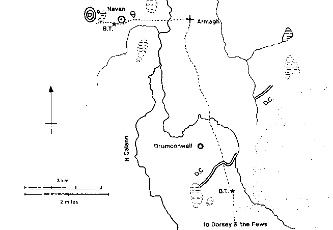
Fig. 3. Location map of Drumconwell showing its relationship to Navan, Armagh, the Danes Cast (D.C.), the Bulls Track (B.T.) and the routeway to the south. Land over 150 m is stippled, lakes and bogs are hatched (R. Warner).
In the ninth century Tripartite Life of Patrick (TPL 238) a reference to a place Oenach Macha in which were a northern and a southern cross. The text is extremely uninformative and we really do not know whether it refers again to Armagh or to another place entirely.
However the earlier Annals of Ulster tell us, under the year 1103, how, in a war between Cenél Eogain and the Ulaid the army of Muirchertach Ua Briain, assisting the Ulaid, was a week besieging Ard Macha against Ua Lochlainn. Wearying of this -
Muirchertach went to Aenach Macha and to Emain and round to Ard Macha...
In other words Aenach Macha, Emain Macha and Ard Macha were different places, though presumably in the same general vicinity.
If these confusions exist in the early texts we cannot guess what place Keating and OFlaherty had in mind when they referred in the 17th century to Oenach Macha as the location of Fert Conmáil. Navan, Armagh or another place in the general locality.
An óenach was a place of secular ceremonial, royal pronouncements and fairs. There is no evidence that any territorial or tribal óenach followed a prescribed physical form, indeed it is extremely difficult to point to any óenach which has been identified with an actual site rather than with a general location. It was not necessarily the same as the tribal capital, indeed was probably intentionally different from it (Binchy, 1958; Warner 1988,57). We should not, then, expect that Oenach Macha was the same as Emain Macha, which was the ritual capital the Ulaid until the 4th century AD and perhaps of the Airgialla after that.
If Oenach Macha were in fact Navan or Armagh, or very close to either, Drumconwell, though south of them is hardly on the south side or juxta either of them. But I am inclined to regard the 1103 reference as overwhelming evidence of the separation of the three places, a sort of triad that Muirchertach had to visit: Ard Macha, Oenach Macha, Emain Macha; ecclesiastical centre, place of tribal assembly, ritual centre. This is at least not inconsistent with our hypothesis - that Oenach Macha and Fert Conmáil were at Drumconwell.
Drumconwell and Navan
A routeway seems to have run roughly south to north across Sliab Fuait (roughly the south Armagh hills, often called the Fews though this name does not derive from the first but comes from Fiodhbadh - a forest). This route seems to have run through the earthwork enclosure at Dorsey (Lynn 1989), then on past Carrigatuke, through Lisnadill, where it is marked by a stone known locally as the Bulls Track, and on to Armagh and Navan. Just north of the Bulls Track the date, old road passes through a linear earthwork, the Danes Cast, that runs south-westwards through Latmacollum, Lisnadill and Killyfaddy. A small excavation on the earthwork at Killyfaddy failed to site provide evidence of date (Lynn 1988) though the position of the earthwork, straddling the same route as the Dorsey, supports the idea that it should be the same date as that earthwork, around 100 BC, and therefore the same date as the Navan 40 metre structure (Lynn 1989). In addition, with a small piece of earthwork north-east at Killeen, this Danes Cast the gives every appearance of defending Navan, as the map shows. The Drumconwell site is just west of the probable line of the routeway and one kilometre north of the western end (as we have it) of the Danes Cast. It some is difficult to believe that this is coincidental, particularly if we are right in regarding Drumconwell as a candidate for Oenach Macha, for the route joins the three places we mentioned above as forming the triad of Macha. Drumconwell is 5km. south of Armagh and 6 km SSW of Navan
Conclusion
The archaeological evidence, insofar as we have any, suggests that the Graveyard Field is the site of some sort of early Iron Age settlement placed close behind the defensive Danes Cast and close to the line of an he ancient road to Armagh and to Navan. This he settlement was certainly undefended, either by artifice or nature. This is not to say it was not demarcated in some way, at a later date perhaps, but no physical evidence survives. Very early in the Christian period a cross-inscribed stone was set up here with an ogham inscription perhaps commemorating a mythical hero, perhaps a local king, perhaps even marking a grave. The field name suggests the discovery of inhumations here at some time (although there are other explanations). It would be tempting to suppose that the site was, at least partly, ecclesiastical in nature, perhaps pre-monastic. Such an interpretation would be extremely exciting for very early church sites are difficult to identify. In support of this hypothesis we have, as well as the cross and the cemetery, the story in the Tripartite Life (if the Oenach Macha connection is accepted). There are a number of early churches mentioned in medieval texts as being in the area of Armagh but which we are now unable to trace. We have to recognise, however, the fact that an inhumation cemetery could belong to the end of the early Iron age, the date of the quern, and this would be unlikely to be Christian (Raftery 1981, 191). A memorial to, or even burial of, a person of high rank before the 7th century would not be inappropriate in a pagan burial ground, especially if that place was of importance for other reasons. If we are right to identify Drumconwell as Oenach Macha, the assembly place of Macha, there is some interest in returning to the entry in the Tripartite Life of Patrick. We read that there were two crosses there, and it takes little imagination to believe that our stone was one of them. We also read that four chariots were brought to Patrick at one of the crosses. One of the forms of entertainment at an óenach was horse-racing, as we learn from the Old Irish testament of Morann - the first immunity [from the legal consequences of injuring another person] is the racing of horses at óenaighe (AM line 71). It surely is not stretching credibility to suggest that the two crosses marked the turning points of the race-course. Interestingly another assembly place, that of the kings of Clogher at Findermore in the Clogher valley in Co. Tyrone, is also described in the Tripartite Life as having two standing stones (TPL 175). They can both be seen today, and one of them bears a simple incised cross (Hamlin 1982,293 & pl.17.4.C). We should also remember that none of the suggested uses of this site - pagan settlement, pagan or Christian cemetery, assembly place - are incompatible. They could have been chronologically separate or they could, to an extent, have coexisted.
I have avoided discussion of the ringforts which are near, and in one case in, Drumconwell. It is my belief that most ringforts are later than the 7th century and fall closer to the 10th. In this case they are not strictly relevant to the topic.
We are left uncertain about the status of the name Conmáel, as commemorated on the stone, remembered in the name of the hill and thence townland, and traditionally believed to have been killed and buried here. We may postulate three alternative scenarios. Our first scenario is as follows. Someone in the 17th century or before read the garbled inscription and concluded, as I did, that it referred to someone of the name of Conmáel. This person then named the hill and located here a mythical battle and the burial place of a mythical character. I do not think we need to take this scenario seriously. The second scenario is that a tradition existed here as early as the 7th century that this had been the site of a mythical battle and that the name of the character was carved on the stone. This tradition, and the identity of the memorial itself (as if it were a grave), survived locally until the 17th century and resulted at some unknown time in the naming of the hill. The third scenario is something of a conflation of the other two. A historical Conmáel, perhaps the king of the Airthir who died in the 7th century, was commemorated here on the stone, perhaps buried here. This tradition, and the location of his grave, survived locally and the hill was named as a result. Much later the identity of the historical Conmáel was forgotten and replaced with the mythical one. Between scenarios two and three I am quite unable to judge.